
A 5-minute version of the latest Condatis paper
‘How to manipulate landscapes to improve the potential for range expansion’ by Hodgson et al.
A new publication led by Jenny Hodgson gives more scientific backup to the methods underlying Condatis. It shows how automatic routines are capable of selecting very efficient arrangements of habitat – which will help decision-makers to prioritise modifications to existing landscapes. We tested the dropping routine (as already used in some Condatis case studies) and a new adding routine based on the Condatis bottlenecks map.
Background
The main aim of Condatis is to facilitate planning habitat networks to enhance very long distance connectivity. It uses a landscape metric called conductance, which is correlated to the speed with which a species can spread through a landscape, from a source location to a target. The source and target can be based on shifts that we believe species need to achieve, for example because of climate change. A key difference between conductance (aka speed) and most other connectivity metrics is that it incorporates both reproduction within habitat patches and dispersal between habitat patches, over multiple generations.
Prioritisation
We investigated how one could gradually modify an existing landscape in order to optimise its conductance between a fixed source and target. If we can find optimal arrangements quickly, given knowledge about the existing habitat, this technique can be placed “under the bonnet” in decision support tools including Condatis. To demonstrate how our techniques function, we started with simplified scenarios. We assumed that the conductance for one species in one direction (south-north) is the only conservation goal for the landscape. We also used 30 demonstration landscapes designed to have a wide range of spatial patterns.
First, we showed how conductance depends on the total area of habitat in the landscape when the spatial arrangement is random (see figure below). It may seem obvious that conductance increases with more habitat, but showing how it increases is still interesting and useful. One implication of this for everyone is that habitat restoration can have benefits even when nothing is known about how to optimise the arrangement: adding habitat completely at random still helps. We also needed this information to prove that our new methods are much better than random at choosing which habitat patches to add or retain.
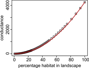 | When habitat cells are added to a raster landscape at random, the conductance increases in proportion to the amount of habitat squared. Squares show the conductance of landscapes with a random selection of cells chosen to be habitat. The red line is based only on the 100% point and the expectation that conductance is proportional to amount of habitat squared. |
Testing dropping and adding
The dropping routine in Condatis can be used when there is a restricted map of possible restoration patches, which planners wish to rank. It starts by assuming that all possible restoration is achieved, and then evaluates what happens to conductance when these patches are dropped from the network, starting with the ones which are contributing least to the “flow”.
In our paper, we showed that the dropping routine is very efficient because we could consistently drop 25% of cells from the demonstration landscapes without losing more than 6% of the starting conductance (see three examples in figures below). In reality this means that significant conservation objectives could be achieved with a reduced amount of land and restoration effort. However, it does not mean that lower ranked patches would not benefit from restoration for many other reasons.
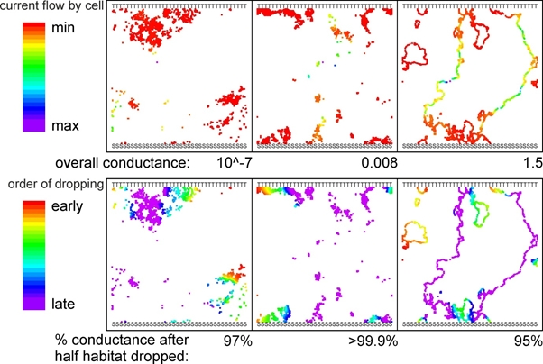 |
| The initial current flow and the outcome of the dropping routine for three example landscapes of low, medium and high initial conductance with 2048 habitat cells (coloured pixels) in a 2048x2048 square landscape. Conductance was calculated between a southern ‘source’ (SSS…) and a northern ‘target’ (TTT…). |
The “power” metric identifies the links which are the strongest “bottlenecks” (called the “bottlenecks map” in Condatis). Our adding routine, which is not yet available in Condatis, automatically identifies the highest power link and places one additional habitat cell at the midpoint of that link, then recalculates and repeats for additional cells. After adding 24 cells to our demonstration landscapes with this routine we increased conductance by a minimum of 24% and a median of 3,800%, whereas adding habitat at random would result in an improvement of only 4.7%. The spatial patterns created by this routine make sense as chains of stepping stones spanning the most significant gaps between the north and south edges of the landscape (see the figure below). The adding routine does not take account of the feasibility of restoration, so we think it is most useful when planners want a priori suggestions of the most efficient places to restore a small number of patches.
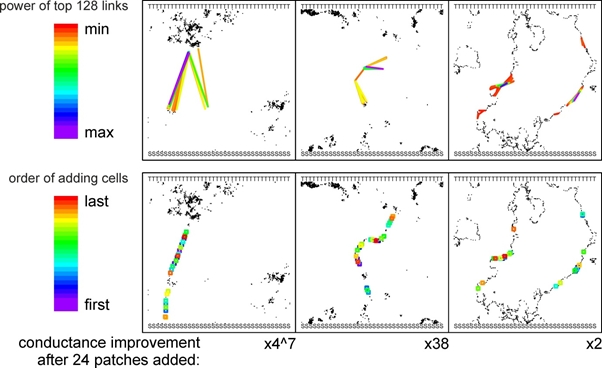 |
| The initial power of links (coloured lines) between patches and the outcome of the adding routine (coloured open squares) for three example landscapes of low, medium and high initial conductance with 1024 habitat cells (black pixels) in a 2048x2048 square landscape. Conductance was calculated between a southern ‘source’ (SSS…) and a northern ‘target’ (TTT…). |
Next steps
The paper is important in demonstrating the effectiveness of the methods underlying Condatis, and their future potential. It highlights that Condatis has moved beyond other methods for visualising connectivity pathways (which do not offer straightforward suggestions for improvement, but see McRae et al) and towards true conservation optimisation tools such as ZONATION and Marxan (which only incorporate very simple connectivity measures). As mentioned, the dropping routine is already implemented in Condatis version 0.6.0, but if you want to check out the adding routine you will have to wait for the next version or look at the R code in the supplementary material (available here). The next steps in this research will be to think about optimising for multiple species in multiple directions, and about prioritising for long-term survival in one place as well as the speed of range shifting. If you are thinking about using, testing, or building on these methods we would love to hear from you.