
A blog contributed by Daneen Cowling, Nature Data Solutions
Canal & River Trust (CRT) manages over 2,000 miles of canals and rivers in England. The waterways run through 32 of the 48 Local Nature Recovery Strategy (LNRS) areas and within five miles of half the population. As one of the few continuous habitat corridors through otherwise fragmented lowland landscapes, the network is uniquely placed to contribute to national nature recovery targets. CRT needed an evidence base to show where, along 2,000 miles of estate, intervention would have the greatest ecological return, and how that lined up with what regional partners were already planning through their LNRS.
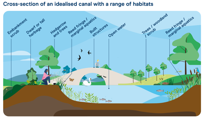
A cross section of typical habitats in and around canals and shown in the Vital Connector for Nature and People report (Canal & River Trust, 2025)
Identifying where the network can support nature recovery
Nature Data Solutions applied Condatis across five CRT operational regions (the North, West Midlands, East Midlands, London and West England), combining CRT’s own habitat survey data with Natural England’s Priority Habitat Inventory. Condatis modelled connectivity for grassland, wetland and woodland habitats at two dispersal distances, and the resulting flow outputs were intersected with Natural England’s national bottleneck dataset to pinpoint where poor connectivity along the canal corridor was most severe, and therefore where habitat work on CRT’s own estate would unlock the greatest gain for species movement.
Nationally, priority habitats along the CRT network intersect roughly 2,400 hectares of bottleneck area, with grassland and wetland constraints concentrated across the Midlands. The East Midlands showed the greatest total intersection (277 km), with the Leicester Line of the Grand Union Canal running through severe grassland bottlenecks for almost its entire length. Wetland bottlenecks affected over 138 km of canal in the West Midlands; and in the North, the Trent & Mersey Canal alone accounted for half the region’s total bottleneck length.
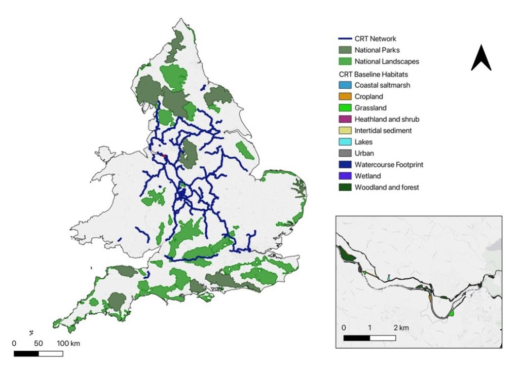
The CRT network mapped against National Parks, National Landscapes and baseline habitat data, showing its role connecting fragmented lowland England
Turning maps into cross-boundary collaboration
The most distinctive part of this project was what happened after the modelling. Rather than handing over a set of maps, Nature Data Solutions ran dedicated LNRS-focused workshops in each of the five regions. Local LNRS teams and CRT ecology and enterprise staff came together around an interactive online map (built in ArcGIS Online Experience Builder) that overlaid the Condatis bottleneck results directly onto each region’s published LNRS measures and the CRT network.
Attendees could see, live, where connectivity constraints identified by the model lined up with the priorities their own LNRS had already set, and were invited to annotate the map directly with project ideas and opportunities as the discussion unfolded.
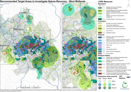
An example output from a West Midlands modelling: recommended target areas where bottleneck severity overlaps published LNRS measures, used to identify opportunities live in the workshop
Every participating LNRS either explicitly names canals or includes measures CRT can deliver directly (e.g. riparian buffering, invasive species control, fish passage improvement, marginal habitat creation). Thus, the workshops turned an ecological connectivity analysis into a shared, cross-boundary conversation about delivery, something no single organisation’s data could have prompted alone.
This evidence-led, workshop-based approach let CRT and regional partners develop relationships and identify opportunities that crossed organisational and geographic boundaries: a joint water vole recovery and mink control programme spanning Nottinghamshire and Leicestershire; a Trent & Mersey invasive species partnership with the Angling Trust and United Utilities; and a Lancaster Canal connectivity project developed jointly with National Highways to address severance by the M6. In several regions, the workshops also surfaced funding routes, including Nature Investment Hubs, HS2 biodiversity funds and Heritage Lottery applications, that partners could pursue together using the connectivity evidence to strengthen the case.
Outcome: a live project pipeline at national scale
Across the five regions, the workshops produced a live pipeline of collaboratively identified project opportunities directly aligned to published LNRS measures, giving CRT a quantifiable, partner-endorsed evidence base to position its network as a priority delivery partner for nature recovery, in support of the Environmental Improvement Plan and the statutory goal of halting and reversing biodiversity loss by 2030.
Client: Canal & River Trust
Delivered by: Nature Data Solutions
For more information please contact:
Richard at Richard.Bennett@canalrivertrust.org.uk
Daneen at daneencowling@naturedatasolutions.com